It's hard to believe my last post was almost a year ago! Running has been going well: no major setbacks, lots of decent training, and a few personal bests along the way.
The first 4 months of each year are always busy with the Island Race Series and the TC10K. This year I decided to add a race that I've never done before: the Sun Run. The Sun Run is a huge race that attracts thousands of runners. The race organizers cap it at 50,000 runners making it Canada's largest road race. This year it is my goal race!
Last fall I read a book called Running With The Buffaloes, which chronicles a 3 month training block of the Colorado University men's cross country team (the Buffaloes) as they gear up for the NCAA 10K Championship. It was an interesting and easy to read book which includes lots of different workouts and helps explain why we do certain workouts. And to see the benefits and downsides of pushing yourself to the limit.
After finishing the book I thought it would be fun and beneficial to replicate the workouts in the order they were done in the book as closely as possible leading up to the Sun Run. The only differences were that I wasn't going to be running 100 miles per week like the guys in the book do, and I would be running a lot slower.
I've entered all the specific workouts into a spreadsheet and shared it in case anyone else wants to follow them: Workouts from the book.
Each week follows a basic format of 4 hard workouts (Tues, Wed, Fri, Sun) and 3 easy or rest days. The hard workouts each week include one long run, one medium long run, and one or two intervals, fartleks or tempo runs.
The training is divided up into 5 stages (modified from Lydiard's teachings) which start after the usual base building phase:
| Period A | 6 weeks | Ascend to full volume: no intervals, tempos, races, etc |
| Period B | 5 weeks | Aerobic short specificity: work done at goal race pace, with full recoveries on intervals (non-anaerobic) |
| Period C | 6 weeks | Aerobic long specificity: longer intervals, still no anaerobic. Longer fartleks, mile repeats, long tempos (10 milers). |
| Period D | 3 weeks | Anaerobic specificity: short fast intervals with very little recovery. Wed/Sun long runs decrease by 10-25% in distance, same speed. |
| Period E | 2 weeks | Anaerobic speed: sprinting and intervals at faster than race pace. |
As part of my training I included 3 Island Races: the Pioneer 8K in January, and Bazan Bay 5K and Comox Half Marathon in March. Partly because they are my favorites, and partly because they are in the Timex Road Race Series. By doing the Sun Run and TC10K in April gives me the minimum required 5 races.
All 3 island races went very well. In each race I ran a negative split and achieved a personal best. At Pioneer I finally broke my old record of 29:03 from 2008 with a time of 28:39. At Bazan Bay 5K I improved by 20 seconds from last year, finishing in 17:01 (my highest race points ever - 764!). Comox was 1:20:29 (70 seconds faster than 2011 RVHM) which wasn't quite the sub 80 minute time I was hoping for but a back injury and lack of long runs were probably to blame!
Last weekend I did one final tune-up race before the Sun Run (which is this Sunday, April 21st) - the inaugural Bob Reid Magical Mile. It was an out-and-back course on the Galloping Goose which had a slight uphill on the way out and a downhill on the way back. It was a fun event which featured some very fast runners and lots of prize money, for them! I placed 4th out of 6 in my 30-39 age group with a decent time of 5:07.
The Sun Run should be an interesting race with it's downhill start, the steep climb over the Burrard Street Bridge (at 5K), and of course the other 40,000 runners!
Here's a look at the route and elevation (click for a larger version):

After the Sun Run there is not much time to recover - exactly one week after it is the TC10K on April 28th!
In my previous post I covered as many of the details as I could think of about what happens before the race starts. This entry is all about the actual race - the excitement, the pain, the heat, and the finish!
GoalsGoing into this race I set 2 goals: finishing under 3 hours again, and enjoying the Boston atmosphere. I've said to a few people that this could well be my last marathon (yes I know we all say that), so I really wanted to enjoy the experience as much as possible, and try to draw energy from the hundreds of thousands of spectators that come out to watch on the holiday Monday that is race day.
I was actually hoping for a time of 2 hours and 55 minutes. This requires a pace of 4:09 per kilometer, 20:45 for 5K, 41:30 for 10K, and 1:27:30 at half way. When the forecast showed 30 degree heat (86F) on the day, I made the foolish decision to not change that goal. Looking back this was probably not a good choice...
The Start (0 - 5 km)I anticipated a slow start due to the 2000 runners who would be lined up in front of me (I was in corral 3 and there was approx. 1000 runners per corral), but I knew that the first 6km was quite steep downhill so I figured once we started to move smoothly I'd easily be able to make up the lost time from a slow start.
It actually wasn't a slow start at all. It took me exactly 1 minute to cross the start line, and although it was very congested we all managed to move pretty quickly. My first kilometer was 3:57 which was a surprise. I was carrying an extra water bottle, and was frequently drinking from it, hoping to chuck it after a few kilometers to let my arms swing freely. I stayed to the left side of the road (which is a narrow street, one lane each way) for the first few kilometers, and this was good because I was able to move past quite a few people. After 1km or so there was a wooded area on the left with some bushes and quite a few runners stopped for a quick pee!
The first bit of chaos happened at mile 2 where the first water/gatorade station was setup. Boston does an amazing job of having water and gatorade stations every mile starting at mile 2. They have them on both sides of the road slightly staggered. This is key because when there are that many runners you simply can't get across to the other side of the road to get water! Well at the first water station I (like many others) was simply trying not to trip on the runners in front, and didn't see the water station coming up. So all of a sudden WHAM, we all ran into each other and slowed right down. Luckily no one around me fell or was hurt, we simply slowed down and carried on. But it was not pleasant. I couldn't even grab a water because I wasn't close enough to the left side of the road.
I finally finished my water bottle around kilometer 4, and was very relieved to chuck it. I hate running with stuff in my hands. It was around this time that a guy wearing a very bright yellow singlet came up beside me and asked if I was from Victoria. This confused me, but I later realized that my red Harriers singlet has Victoria, BC on the back, duh. Anyway, it turned out to be Geoff Courtnall (formerly of the Vancouver Canucks and other NHL teams) who is also from Victoria! I knew he had run a 3:03 at Victoria to qualify and was running Boston raising money for charity. For every minute he ran Boston under 3:10 he'd donate money to charity ( full details). We chatted for a couple minutes while we flew past many runners (I definitely picked up my pace a bit to stay and talk with him!). Then he slowly pulled ahead of me and I lost sight of him. While I wished him the best of luck, I was a little surprised that he'd be going out so hard...
Coming up to 5K I was trying to slow myself down because I knew I was ahead of pace, but despite the heat things felt okay so I wasn't too concerned about being 20 seconds fast. My splits were: 3:57, 4:11, 4:04, 4:15, 3:54 for a 20:22 split (4:04 pace).
5 - 10 kmThis next section is where things started to get harder. Way too early to be feeling crappy right? I was drinking water and a gatorade at every water station. It wasn't as crowded now, and the streets were a little wider too so there was more room to move which was nice. Many runners started to run almost single file along the right side of the road because it had slightly more shade from trees and small buildings.
I had some pain in my lower back as we neared 10 km, and that definitely didn't help keep my spirits up. I was also getting annoyed with my fuel belt digging into my stomach and sliding around my waist. It was a tough choice - do I wear the fuel belt to carry extra water/energy drink and hold all my gels (7)? I don't like wearing a belt, but I thought on such a hot day the belt was a good idea to have a little extra liquid and to hold the gels. But it is not comfortable at race pace, it slides around and digs in, and generally annoys me. Anyway, during a marathon these little things can really drag you down if you're not careful. I had planned on dumping the 2 fuel belt water bottles once I finished them, and then dumping the fuel belt too (and carry the remaining gels in my hand).
I knew I was going a little slower during this section, but I thought this was good to balance out the first 5K. My splits were 4:05, 4:12, 4:14, 4:20, 4:13 for a 5K time of 21:04 (4:12 pace). At this point (10K) I was exactly on my goal pace with a time of 41:26 (although looking at my results I actually crossed the official 10K line at 41:39).
10 - 15 kmIf I really had any belief that I could run a 2:55 in the heat, that changed during this section. I dropped a full minute over these 5 kilometers, and basically felt like crap. My back was still aching, and I just wasn't moving well. My splits were 4:22, 4:26, 4:25, 4:18, 4:25 for a 5K time of 21:54 (4:23 pace). Way off goal pace.
I have to say that the crowds were pretty amazing. Apart from a short section just after the start there were people lining both sides of the street the whole way. In residential areas it was families camped out on their front lawns offering oranges, water (often ice cold), or spraying you with water from a super soaker or sprinkler. In commercial areas people lined the sidewalks cheering and screaming for everyone. The ice cold water cups and bottles were the nicest surprise, since most of the official water stations had been setup for hours and were serving luke warm water.
15 - 20 kmThis section was no better than the last. The only good thing about it was the "Scream Tunnel" right at 20 km where thousands and thousands of girls from the Wellesley College lined the right side of the road where the college is. It is infamous. Everyone told me you have to run on the right side through Wellesley! So I did, and it was unbelievable. If I was single I would have definitely slowed down for a kiss. I high-fived almost everyone, and really enjoyed reading all the creative signs such as "Kiss Me! Don't worry, you're faster than my boyfriend", "I majored in kissing", "It's hot, but so are you!", etc. I especially enjoyed seeing an 80 year old woman at the end of the tunnel with a "Kiss Me" sign.
Apart from that there isn't much I remember. There was some nice shady sections as there was a park on the right side I think? My splits were 4:31, 4:27, 4:35, 4:26, 4:40 for a 5K time of 22:39 (4:32 pace). By now my overall pace was 4:18 and I knew before half way I would be going well over 3 hours.
20 - 25 kmSince the Boston Marathon has more of the downhills in the first half, I wanted to be slightly ahead of pace at half way. That way I could handle losing a minute or two in the Newton Hills which are from 25 - 33 km. Well when I got to half way and the clock read 1:31:23 I knew that wasn't a good sign! Marathons are hard to begin with, but the extra difficulty of trying to stay motivated, stay positive, keep pushing etc gets even harder when you aren't running well. If I had a clear mind I might have realized that a 1:31 half in the heat is very good, and a sub 3:05 finish is still possible (which is the Boston qualifying time for my age). But I was not thinking clearly, and still fixated on my goal of 2:55 which was long gone. So instead of taking some positives, it was all negative.
By now I had finished both the water bottles in my fuel belt, and chucked them. My strategy was to have 1 gel every 5 kilometers, so I had already taken 4 and only had 3 left for 25, 30, and 35. Somewhere during this section I decided to just chuck the whole belt too and carry the remaining gels in my hand. I definitely felt a little better, and managed to run a little quicker. A couple times I put some ice cubes under my hat which was nice as I was definitely over heating and feeling that extra bit more fatigued due to the heat (and maybe the fast start). Before 30 km I had also chucked my hat because I was too hot - a nice souvenir for some lucky spectator (or dog).
Somewhere in this section I saw a runner getting put on a stretcher and carried off the course. Ugh, not a good sign.
Being free of the fuel belt seemed to help my splits too, as my times were 4:28, 4:22, 4:24, 4:25, 4:39 for a 5K of 22:18 (4:27 pace), slightly faster than the previous section.
25 - 30 kmRight around mile 16 and kilometer 25 the course goes down a nice steep hill before crossing the Charles River. This is a low elevation point and the start of the Newton Hills. From here the next 8 km are definitely the toughest section of the course. People generally say there are 4 Newton Hills (see the Elevation Profile). Each one is roughly 1 km of uphill followed by roughly 1 km of gradual downhill with the 4th hill being Heartbreak Hill which is the steepest. I was prepared for these hills (many runners from the West Coast had told me that these were pretty small hills) and did a decent job of keeping up my pace. My splits might not reflect that, but I think it was a decent effort. The first 3 hills were definitely nothing serious at all, they just dragged on a bit. I kept looking at my watch wondering why it was taking so long!
30 - 35 kmThe couple kilometers before reaching the summit of Heartbreak Hill (at 33 km) seemed to drag on forever. I didn't stop once and still managed to keep moving reasonably well right up the steepest section of Heartbreak Hill, and gave a little yell when I finally reached the top. There is a nice steep downhill after Heartbreak, and more gradual downhill the rest of the way until the final mile. On a good day this would have been the section to take advantage of and make up some lost time. I didn't. By this point I wasn't even looking at my watch, and I had a whole new game plan now - just finish (or "get er done" as Donald would say!).
My splits were 4:42, 4:51, 5:08, 5:17 and 4:41 for a 5K time of 24:41 (4:55 pace).
35 - 40 kmIt's not good to admit it but I had definitely lost all motivation to keep trying at this point. Each kilometer was getting more painful and dragged on and on. And even though the crowds of spectators were getting louder and bigger the closer I got to the finish I couldn't find any way to get motivated to pick up the pace. In my head I had long since realized that a sub 3 hour was gone, a sub 3:05 was virtually impossible. So there really wasn't that extra incentive to dig deep. To me a 3:06 and a 3:15 were the same, and the 3:15 sounded a lot better :) I'm sure many other marathoners have reached this same conclusion!
The roads were so wide at this point that there really weren't many runners around. It felt like tons of runners were passing me (and they probably were), but I think I was actually passing more people. At one point right around 40 km a guy running right beside me face planted on the asphalt. He must have tripped on an uneven section or something. I wanted to stop and help, but in that super fatigued state I didn't want to stop moving since I felt pretty wobbly myself. There were so many spectators I'm sure someone rushed to his aid and hopefully he was able to get up and finish.
Not that you care, but my splits for this section were 5:12 (ouch), 5:12, 5:23 (double och), 4:37, and 4:58. That made for a 25:21 5K (5:04 pace). I honestly don't remember too much during this section. It was a blur, I just keep running and wishing that the turn onto Boylston would hurry up and get here.
40 - 42.2 km (Finish)Right at 40 km I must have been running beside Geoff Courtnall since our times were 1 second apart (he had been ahead of me since before 5 km), but even with his bright yellow singlet I didn't see him. He obviously suffered in the heat too and faded to finish in 3:14:xx. I had my head down and was shuffling my way towards the finish so I guess it wasn't a surprise that I missed him.
There is a nasty little underpass around 41 km where we ran under a road and back up again. It wasn't much but it still sucked. But the good news was I could finally see the turn on to Hereford Street, which meant I was only 1 km from the finish!
Hereford is a slight uphill, but once I rounded that final left turn on to Boylston a huge grin broke out on my face, and I started to run, finally. I knew my wife was cheering on the right side of the road (the shady side), so I crossed over to that side and sprinted down the final 650 m to the finish. There were so many people that I simply couldn't scan them fast enough to spot her, so sadly I didn't see her. But I still appreciate her being there and holding up the sign:
"Chris 'Chariots of Fire' is NONSTOPPABLE".
My finishing time was 3:13:30. A nice number. Not a time that I would have chosen, but all things considered it is a time I'm proud of. The experience was something I'll never forget - the whole event, the spectators, the heat. It was definitely the most unpleasant race I've done though, and does re-affirm my plan of not running another marathon. Apparently the first thing I said to my wife when I saw her after the finish was "Don't ever let me do this again". But apart from the heat and a bit of back pain I really didn't have any major physical problems during the race. It was just too f*cking hot.
Post RaceIf you want to look up any results, here is the Searchable Results Page. My bib number was 2849.
It was freakishly hot at the finish line - the pavement, the buildings, it all made for a very unpleasant feeling. We were herded down Boylston were we were given our medal, a shiny space cape, water, gatorade protein drink, a banana, and some protein bars. Eventually I made it to the bag check area and the nice volunteers gave me back my bag (very quickly, they had it ready for me before I could hobble over to the bus). I had to stop a couple times and lean up again various trucks, but eventually made it to the family meeting area. I texted my wife and lay down in the shade.
We had to walk about 2 km back to our hotel, but it actually wasn't too bad. The heat in the direct sun was still unbearable, but walking actually felt pretty good. The rest of the day I mostly napped, ate some delicious junk food, and took a couple cold showers/baths (since I was still over heating from a bit of heat stroke). By about 9pm that evening I was feeling okay enough to walk around (with medal on of course). The atmosphere out on the streets was amazing, so many people said congratulations. Anyway, that's about all I say about Boston. Will I go back and run it again? No almost certainly not. Once was enough. But it is definitely an experience I would not have wanted to miss.
There is so much to say about the Boston Marathon that I'm going to split it into two separate posts. This post will be on the pre-race details - the expo, getting to the start, athlete's village, etc. The second post will focus on actual race and how it went for me.
ResourcesThere are many websites and forums out there with tons of useful tips from very experience Boston Marathoners, so be sure to check them out (I list a few in my previous blog post).
The official BAA website has a lot of good resources too, like the Participant Information page, Pre-Race Information page, and Spectator Guide.
Hotels And Rental OptionsOnce you've been officially accepted to the Boston Marathon, it's time to book a place to stay. There are many hotels right near the finish line which are super convenient but be warned they can cost $300 or more per night, so you might want to look for other options. I found the AirBnB website very helpful, and ended up booking a furnished suite for $150/night which was only 1km from the finish line.
Here are a few rental websites for Boston:
Training TipsDuring the months before the marathon make sure you become familiar with the race route and elevation. It is not a typical marathon in that it is a point-to-point race and a net downhill elevation change. So make sure your training includes some downhill workouts, otherwise your quads will probably give out on you long before the finish.
If you really want to geek it out, you might also enjoy reading some tips on Boston Marathon Race Strategy to help keep you focused on how to perform your best on race day.
Weather and Packing TipsAs the big day approaches, make sure to follow the weather forecast to have some idea of what to expect on race day. One big uncertainty about the Boston Marathon is often the weather. Since it is in April the weather can be anything from snow to extreme heat. This year (2012) it was HOT - 25-30 degrees (a record I think). So unfortunately this makes the race much harder as well as the planning, and you have to bring a lot of extra running clothes to be prepared for anything.
TransitFor transit (bus and subway) information while in Boston, visit the MBTA website to plan out how to get to various parts of Boston, like the race expo, pre-race dinner, etc. The subway has many different lines running through downtown, and to get you to/from the airport.
Be warned that the subway will most likely be PACKED the whole weekend. I found it very slow, and often couldn't even get on the first train that arrived because it was already full. So expect your trips to take longer than what the MBTA website says.
Race Expo (Friday - Sunday)After you've arrive in Boston you'll most likely want to go to the Race Expo as soon as possible. It is a 3 day event which takes place all day Friday, Saturday, and Sunday. This is where you pick up your race number ( **make sure you bring your race number pick-up card to the expo!). The expo is huge as you might expo, so plan on spending many hours there. There are lots of good deals (like $50 for a pair of shoes) and way too many people, so go to the bathroom before you get there. If you want to go to the pre-race or post-race dinners, this is where you pick up any extra tickets for friends and family who aren't in the race. Tickets for participating athletes are in your race package. As mentioned above the transit was pretty slow the whole weekend, especially getting to and from the expo. What should have been a 20 minute trip took an hour for me.
Sunday (5K, Mile, Pre-Race Dinner)On the Sunday (the day before the race) the BAA 5K race takes place right downtown starting (and finishing) on Boylston Street at 8am. The Invitational Mile happens at the same location at 9:30am.
All entrants get free entry into the Sunday Night Pre-Race dinner. This year it was held at the City Hall at 4:30pm. There was a long lineup, but it moved quickly. The food was pretty basic but still tasty - 3 kinds of pasta, salad, rolls, water, pops, and a goodie bag containing some chocolates and snacks. The Mayor and Race Director both gave speeches (while we waited in line before getting our food), and warned us not to race because of the heat! Naturally we ignored the warnings... There were tons of 8 or 10 person tables set up, so we sat down and were joined by some other runners who turned out to be from Vancouver! Small world.
Race Day (Monday)All participants are told to take the School Buses from along the Boston Commons (Tremont side) between 6:00 - 7:30am. Check out the Pre-Race Info for full details.
Be warned that it will take about 45 minutes to wait in line to get on a bus, and then about another 45 minutes for the bus to make its way out to Hopkinton to the Athlete's Village near the start line. But don't worry, there are a TON of buses, so you'll get on one eventually.
Athlete's VillageHere is a list of some of the things I brought (or considered bringing) to Athlete's Village:
- Sunscreen
- Hat or sunglasses
- Disposable blanket/tarp/garbage bags to put on the ground on the grass or dirt
- Ear plugs or mp3 player to drown out endless announcements
- For males - an empty wide-mouthed bottle for last minute pee
- Toilet paper in case the port-a-johns run out
- Disposable clothing if cold - bring or wear old sweatpants, sweatshirt, jacket, gloves, toque, etc to keep you warm before the start. Any clothing you don't check and don't want to keep will be donated to charity. When you leave the village, there will be volunteers everywhere with garbage bags to collect clothing/blankets etc.
- Your official bag check bag (which you get when you pick up your bib number) with all the stuff you might want at the finish line:
- Post race food/drink (At the finish I got a water bottle, protein drink, banana, and some energy/protein bars)
- Money
- Cell phone
- Change of clothes
 The Village is just a school (actually 2 schools), so you'll be outside on the grass. A tarp or blanket is a really good idea if you get there early and want to lie down. There is loud music and announcements, some food/drink, and lots of toilets. I found the line-ups for the port-a-johns were very short (2 minutes) when I first arrived around 8am, but got longer and longer nearer to the start time. This is why I suggest above to bring a empty gatorade bottle to use in case you need a last minute pee and the line-ups are too long!
There is also quite a bit of shade if you want it. I put down my blanket in the shade behind one of the school buildings, and lay on the ground for an hour listening to music to relax.
Bag Check & Walk To Start LineWhen your wave and corral are called (usually about 40-50 minutes before your start time), it is time to start walking down the the start line (about 1.1km away, maybe 15 minutes?). As you leave the Village you will see tons of the same Yellow School Buses in the parking lot. This is the bag check area - each bus is clearly labeled with a range of Bib Numbers. So find the bus that matches your bib number and give them your official bag check bag (the same bag that contained your bib number that you got at the expo).
Because it was such a hot day I kept a long sleeve white shirt on as I walked to the start line (I tossed it to a volunteer just before the race started), and also carried a water bottle with me. There is some shade at the start line, so I waited under a tree for about 20 minutes before moving into place near the front of my 3rd corral.
That about sums up my pre-race experience. The next blog post will cover the race and post-race details.
Next Monday April 16th I'll be running the Boston Marathon!
Training
My training has gone pretty well, and I'm very excited about the upcoming challenge of another marathon. My training goals this time were more long runs (8 over 30 km), more tempo runs at lactate threshold pace (10 at ~4 min/km), higher volume in general, and more up and downhill training (since Boston has a lot of downhill).
The other difference this year was I've done a lot more races than normal. I did 5 Island Race series, including a great PR at Bazan Bay 5K in 17:20. The other 4 races I took a little bit easy to not affect my training as much.
Weather
So far the weather is looking to be rather hot, with highs in the low 20's on race day. That does make hydration more difficult, but I'm hoping that my last year's BQ marathon the North Olympic Discovery Marathon which was also in the low 20's will be a helpful experience. Definitely wearing sunscreen this time...
Boston Marathon Tips:
In my research about the marathon I've come across a lot of useful resources, especially for first timers:
Boston Marathon Elevation
The elevation profile is something that makes Boston different from many other marathons. It is a net elevation loss (meaning more down than uphill) of about 450 feet (140 m). But this definitely doesn't make it any easier, most people will tell you that all the downhill is what makes this a difficult marathon - it really beats up your quads early on in the race and makes it very tough during the final 10 km.
Simple:
 Detailed
:

Over the first 7 km (4+ miles) the elevation drops about 100 meters (from 150 down to about 50 meters)! After that the elevation doesn't change significantly (undulating) until just before the 25 km mark (15.5 miles) where there is a steep downhill of about 30 meters over 0.6 km. This is the start of the Newton Hills - a series of 4 hills ending in Heartbreak Hill. The first Newton hill is about 1 km long, and 25 m elevation. The second hill is shorter - maybe 0.4 km long and also 25 m up. The third hill is about 0.6 km long and 20 m up. And finally Heartbreak Hill is about 0.7 km long and 28 meters up. After each of the 4 hills there is a downhill section, so that should help with the recovery. Definitely don't want to lose too much time on the uphills! After Heartbreak Hill it is almost all downhill to the finish (minus a few overpasses/underpasses) - about 60 meters down.
Funnies
I also came across some funny signs that people have seen during marathons, from this forum:
 Harden/Hurry The F Up! Harden/Hurry The F Up!- A sign that said "Your wife just called....", then another guy about 10 feet further down the road with a sign saying "She said run faster".

Sure seemed like a good idea 4 months ago...
Here are the post-race blog posts - pre-race and race details.
Do you own a Garmin GPS watch or like pretty graphs? If so then read on!
 I have the Garmin ForeRunner 410 GPS watch which I use for all of my running adventures, it is a very fun toy. All the data from Garmin ForeRunner watches automatically get uploaded to the Garmin Connect website which does quite a nice job of displaying the activities - showing a map of the route, and showing the elevation, pace, and heart rate graphs.
But I'm a web developer so I decided to take it one step further! I've designed a web application which I call Garmin Activity Explorer that lets you analyse public/shared Garmin activities in more detail than you might want.
The main reason why I developed this tool is because I was training for the North Olympic Discovery Marathon, and I wanted to be able to get a good feel of the route since I'd never run the course before. I found a few other people who had run that marathon in previous years and shared their Garmin Connect activities. This allowed me to see the elevation profiles, but I wanted a better sense of how steep the hills were (up and down) and exactly where they were.
The main feature of the Garmin Activity Explorer is that instead of drawing a solid red line on a map to show the route, it divides the line into many tiny segments which get color coded based on one of four properties:
- elevation
- slope
- heart rate
- pace/speed
This way you can easily see the route, but you can also see where the difficult or easy sections of a course lie.
Here are some screenshots of it in action. The green S marker is the start of the route, and the red F marker is the finish.
Elevation Line Renderer
The first screenshot shows the Times Colonist (TC) 10K route that goes around downtown Victoria. In this example the route is color coded based on the elevation above sea level. Blue and green represent low lying areas, and orange red represent higher elevations (although this route is pretty flat).
 Pace/Speed Line Renderer
Similarly, here is the same route but this time it is color coded based on running speed or pace. Red represents slower running, and blue represents faster speeds. By default the line is coloured using the pace at each point, but you can change the segment distance to something like 1000 m to see your kilometer splits. In this example I actually used 2000 m (divided the 10 km race into 5 segments).
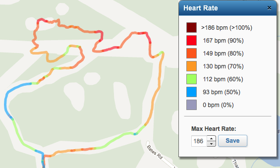
 Heart Rate Line Renderer
A route can also be color coded based on the user's heart rate, but in the example above it makes for a very boring screenshot because the heart rate was between 90-100% the whole race, so the route ended up just being a solid red line! So instead here is a screenshot of a route running and down up a nearby mountain (Stewart Mtn). The line is coloured based the user's heart rate.
 Slope Line Renderer
The fourth line renderer option is the slope renderer. It divides the route into small segments (defaults to 100 m) and calculates the slope (how much elevation is gained over the 100 m) for each segment. The line is coloured based on how steep the slope is - green for downhill, red for uphill. I find this to be a very useful choice because it gives you a good sense of how steep the hills are.

The above screenshot also shows red markers at the 5 steepest uphill slopes, and green markers at the 5 steepest downhill slopes. You can click on the markers to get more details.
Here are a few other features:  | Kilometer markers - markers at each kilometer and halfway |
 | Minimum/Maximum value markers - at the extreme values for the current line |
 | Charts - elevation/pace/heart rate line charts (like Garmin Connect), heart rate pie chart |
 | Data - data table of the raw data points, lap data (splits), and activity details. |
* The Data window details tab shows your final 100m time! This is not necessarily very accurate, it finds the closest data point to being 100m from the finish line, and estimates what your actual 100m time would be. So if you didn't stop your watch right at the finish it might be off by a bit. You can also double click on any data point or lap and it will show you that location on the map. For the laps, it shows the start of the lap.
Here is a screenshot of the charts. Each item in the legend on the right hand side can be unchecked to not display a certain line.

 Getting Started
When the application loads, you will be presented with a window asking you to load an activity. There are 3 tabs on this window that let you import an activity in different ways: - Directly from the Garmin Connect website - all you need is to enter the 8-10 digit id of the public/shared activity (copy and paste from your browser's address bar). These ids are saved for you when you next come back, so enter a title for the activity to help remember.
- From a specific user - if you know the Garmin Connect username, then enter it and click Load. This will load the user's 10 most recent public activities.
- From a local file on your computer - you can export any Garmin activities as a TCX file and save to your computer. These files can be loaded into the application from the 3rd tab.

After you've chosen the activity then choose which line renderer you want to use (this can be changed at any time later) and click the yellow Download button.
When a route has been loaded and is displayed on the map, you may click at any point along the line to get the details - what was the distance from the start, the elevation, pace, etc. It is linked with the Charts view, so you can click on the chart and see where it is in the map, or click on the map to see where it is in the chart.
Another easily missed feature is the Kilometer markers. If you click on any of the markers you will get lots of information about that location: what was the running time, elevation, pace, etc. The halfway point is marked with a blue marker which lets you easily determine your halfway split!
 Comparing Routes
I've recently added a new feature for comparing two or more routes. Once you've loaded one activity, you can click the Load New Activity button and the top and choose a different activity. Before you click the download button - check the Compare against current route checkbox. This will draw both routes on the map. The first route can be coloured and displayed in the charts view. The second (third, fourth, etc) route is coloured in a different solid color. Why would you use this feature? It's great at comparing the same course from two different watches, or for comparing two different but similar courses (e.g. when a race changes the route slightly).
For example, here is this years Gunnar Shaw Race. If you then go and Load New Activity and enter in this activity id 58258801 and check the compare checkbox, you'll see how the route changed from last year (no puddle!) to this year.
A few more things to note - in the top right corner of the map are 5 map type choices - the default Google Map, Satellite, and Hybrid. And then there's two other neat ones - Terrain and OSM (Open Street Map). The OSM map type is very good for showing trails.
When you load a public Garmin Activity your browser address bar URL will change to include the activity id, line renderer, and km markers like this:
.../GarminMaps.html#gid=82783960&km=on&rid=elevation
This means that you can bookmark and share any public activity.
Anyway, this is much too long for anyone to have actually read. But I welcome feedback and suggestions. Please feel free to tell your friends who use a Garmin GPS watch (or any other one that supports the TCX file standard) about this site if you thinks it's useful.
Here is the link to the application:
Garmin Activity Explorer
After my last marathon (the North Olympic Discover Marathon, or NODM for short) I did what most runners do - I said I'm done with marathons, never again! But a few months later I realized that I had qualified for the Boston Marathon and since the qualification times are getting harder I decided this was my best opportunity to run Boston. So I've now registered and been accepted to run Boston on April 16th, 2012!
As usual my first order of business was to start looking at the route and comparing the elevation profile to Victoria and NODM. Here is the graph I made showing the elevation profiles for the 3 marathons: As you can see it has a lot of downhill to start the race, and then a tough section from 25km - 33km, and a nice downhill to finish. Anyway, that's all I have to share so far, more later.
I've now run three marathons - the Royal Victoria Marathon in 2007, the North Olympic Discovery Marathon in 2011, and most recently the Boston Marathon in 2012. I kept very detailed logs about my training for each one, so here is the comparison. In each case I did 5 months of focused training. So a lot of the numbers displayed below are the totals for the 5 months leading up to the race.
| Stat | RVM 2007 | NODM 2011 | Boston 2012 |
|---|
| Total distance | 1288 km (* no GPS) | 1243 km | 1424 km |
| Total time | 111 hours | 115 hours | 134 hours |
| Races | 7 (4 km, 6 km, 8 km, 10 km, half) | 4 (800m, 5 km, 10 km, half) | 10 races (5 km, 8km, 10km, 15 km, half) |
| Runs > 20 km | 8 | 11 | 14 |
| Runs > 30 km | 4 | 6 | 8 |
| Longest run | ~34 km | 36 km | 37 km |
| Highest weekly km | 92 km | 120 km | 122 km |
| Tempos (<4:30) | 1 | 18 | 21 |
| Yasoo 800s (10x800m) | 2:58, 2:58, 2:57, 2:57, 2:55, 2:52, 2:55, 2:53, 2:47, 2:55 (Avg 2:55) | 2:51, 2:47, 2:45, 2:41, 2:42, 2:39, 2:40, 2:41, 2:44, 2:22 (Avg 2:41) | 2:49, 2:51, 2:47, 2:46, 2:45, 2:40, 2:41, 2:44, 2:41, 2:30 (Avg 2:43) |
| Goal | Sub 3 hours | Sub 3 hours | 2:55 |
| Race day weather | Mild, ~12 °C, rainy in 2nd half | Sunny and hot - ~20 °C (sunburn on back) | ~29 °C, brutally hot |
| Marathon result | 3:02:56 (1:29/1:34) | 2:59:45 (1:29/1:31) | 3:13:30 (1:31/1:42) |
* I have a feeling that my 2007 distances were slightly inflated since I didn't have a GPS watch, and so I could only guess how far I ran based on how hard I was running and how long it took.
My Garmin Connect activities are public and can be viewed here: NODM, Boston.
I didn't have a GPS watch for the 2007 marathon, but I found a lot of other people who have run the Victoria course, and I combined the elevation profiles for the three marathons here. You can see that the NODM course has a lot more elevation drop, but it also has some very steep uphills too. The RVM course is flatter in general, but has lots of undulation. And Boston is mostly downhill except for the Newton hills from 25 km - 33 km.
|